Future Land Use Element

The video below gives an overview of the Future Land Use Element of the comprehensive plan. A presentation of proposed changes and public meeting on future land use will be held on Monday, October 17th, 2022 at the City of Bowling Green Neighborhood and Community Services building at 701 East Main Avenue at 5:30 PM in the community room. A link to the plan element, proposed changes, Future Land Use Map proposed changes, and other resources are provided near the bottom of this page.

This video contains an overview of the Future Land Use element of the Focus 2030 Comprehensive Plan, some updated land use statistics, and provides commentary on some topics concerning land use in our community.

This is a video of public meeting and presentation held on Monday, October 17th, 2022 at the City of Bowling Green Neighborhood and Community Services building at 701 East Main Avenue at 5:30 PM in the community room. Staff presented an update of current and proposed land use statistics and the proposed changes to the Future Land Use Element. The presentation in the video be found here.

Proposed Changes to the Future Land Use Element
  • Updated Quick Facts with 2022 numbers (page FLU-1)
  • Various pages – changes to element to include updated numbers
  • Updated Existing Land Use Maps Figure FLU-1 and FLU-3 (page FLU-3,4)
  • Updated Future Land Use Map Figure FLU-4 (page FLU-6)
  • Action LU-1.1.2
    • Revised Agricultural FLUM category description to include natural areas and RR zoning as an identified possible zone in this category (page FLU-8)
    • Clarified that the Rural Density Residential FLUM category is applicable in areas with adequate infrastructure availability (page FLU-8)
    • Removed conservation subdivision reference in the Low Density Residential FLUM category (page FLU-9)
    • Replaced acceptable density range of 3.5 to 13 du/ac with a density cap of 13 du/ac in the Moderate Density Residential FLUM category. This adds flexibility to allow lower densities in instances where the Planning Commission deems a lower density to be acceptable (page FLU-9 and FLU-11)
    • Added flexibility in the High Density Residential FLUM category for single family uses, along with flexibility for lower densities if the Planning Commission determines that a lower density is compatible. Clarified that limited commercial uses may also be appropriate in this category (page FLU-9)
    • Added flexibility in the Mixed-Use/Residential FLUM category for limited HB zoning in excess of 10,000 sq. ft. in urban areas where more intense commercial uses are already prevalent, and where the Planning Commission determines that the proposed use is compatible (page FLU-10)
    • Clarified that complementary light industrial uses may be appropriate in the Mixed-Use/Commercial FLUM category (page FLU-11)
    • Added cemeteries to the Open Space, Parks and Recreation FLUM category (page FLU-11)
    • Removed commercial percentage limitations in the Rural Village FLUM category (page FLU-11)
    • Added RS-1C and RS-1D as potentially compatible zones in the Low Density Residential FLUM category (page FLU-11)
    • Removed lower end of the density range for the Moderate Density FLUM category (page FLU-11)
    • Added RS-1C, RM-2 and NB as potentially compatible zones in the High Density Residential FLUM category (page FLU-11)
    • Added RM-4 and HB as potentially compatible zones in the Mixed-Use/Residential FLUM category if the Planning Commission deems such zones to be compatible (page FLU-12)
    • Removed residential percentage references in the Rural Village FLUM category and replaced with flexibility to allow the Planning Commission to determine what is compatible (page FLU-12)
  • Action LU-1.1.4
    • Added additional exception from FLUM compliance for single family residential rezoning requests that are determined by the Planning Commission to be compatible with existing residential land uses, and where no more than four lots are being created from a parent tract that existed prior to July 1, 2001. The parent tract does not have to be a nonconforming parcel less than 5 acres. The previous exemption only allowed subdivision of one additional lot from a nonconforming parcel less than 5 acres (page FLU-14)
  • Click here to see element with changes highlighted in yellow and/or red text.
  • Future Land Use Map. Click an option below to see proposed changes to the Future Land Use Map:

Each .pdf map has layers you can turn on or off if your software allows and you know how to use it. All four options are the same data, just different ways of displaying the proposed recommendations.

Questions

Where do you think growth will occur over the next 10 years?

How can we limit the number of FLUM changes going forward?

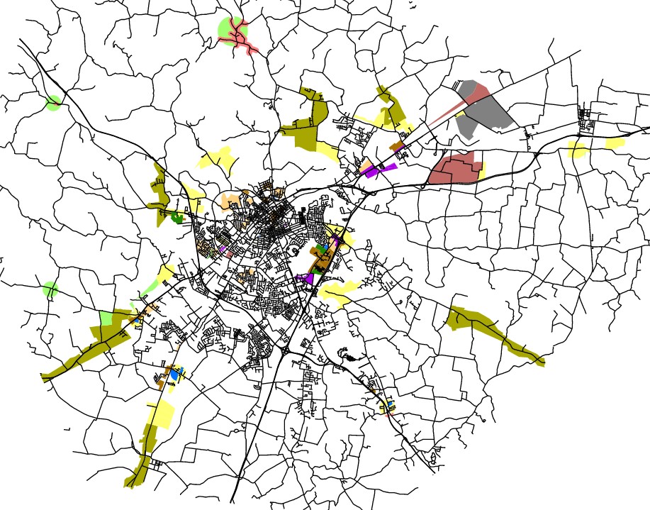
Proposed FLUM Changes

Click the image to go to a GIS web map of the proposed changes. To see a .pdf of the proposed changes click the links to the maps under the Proposed Changes to the Future Land Use Element heading.

Questions & Answers / Comments

Please email us at planninginfo@bgky.org with a subject of “Session 9” to submit a question or make a comment specific to Session 9.